|
|||||||||||||
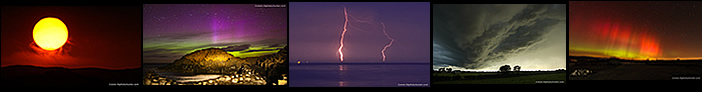
2024 was the year when the night sky took centre stage producing some of the finest celestial wonders I have ever seen in my life. Many beautiful aurora displays, two of which were epic visual shows which I rate among my personal best displays ever seen in 26 years. Then an stunning solar max rare Noctilucent Cloud display on atmospheric steroids thanks to the Hunga Tonga undersea volcanco, this ranks as my joint best display ever. Followed by the brightest comet in 27 years C/203 A3 Tsuchinshan-ATLAS complimented by several thunderstorms, a huge funnel cloud and beautiful Winter scenes.
| My first chase of the new year. On January 17th 2024 I woke to a frozen world with -4C temps and a layer of snow, trusting model guidance I drove north after sunrise to get into a better location for snow showers and instability. During a break in Garvagh a large convective snow cell approached from the coast and began making its way inland towards me. I got the drone in the air and for the next 30 min's got treated to an impressive sight of this mean cell dropping dramatic snow curtains across the Winter landscape. This was followed by a visit to the north coast where I obtained aerial footage of Binevenagh covered in snow with spectacular low cloud and fog covering the peaks complimented by a glory. This turned out to be a highly rewarding and photogenic Winter chase. One page report with 22 images and 2 video clips. - REPORT. | 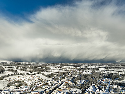 |
| This report covers days two and three of the January 2024 Arctic cold spell across N. Ireland. On the 18th while in Dungiven a snow devil formed and actually impacted us while we stood outside before crossing the road while rotating through a garden then vanishing, this was followed by heavy convective snow showers over Glenshane Pass. On the 19th I discovered that much of Lough Fea was covered in ice for the first time since 2010, the view from the drone revealed beautiful abstract patterns which were fascinating to observe, nature's art. Also on show was an optics display surrounding the sun poised over the frozen lake. One page report with 12 images and 1 video clip. - REPORT. | 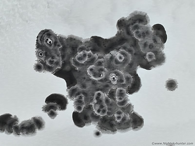 |
| On March 3rd 2024 a CME glancing blow from a filament eruption arrived delivering a G1 geomagnetic storm. At first the potential didn't look good with a slow solar wind speed however a sustained period of southerly Bz at -14 really got my attention. I almost didn't go aurora chasing however a hunch told me to make the effort to drive to the north coast to avoid advancing cloud. After filming an impressive rainbow with the drone I then drove to Benone beach. Upon arrival the aurora went into a dramatic outburst reaching G2 levels with vibrant rays reaching 70 degrees high with green and red colours visible to the naked eye. As the aurora danced I observed comet 12P/Pons-Brooks from the beach, at one stage the aurora was with the comet at same time which made for a fabulous experience. This aurora caught me completely by surprise, an exciting and photogenic event. One page report with 14 images. - REPORT. | 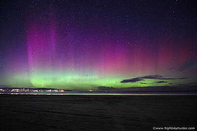 |
| First storm chase of 2024 which began with a bust day on March 29th then on the 30th I teamed up with Colleen Webb on Glenshane Pass to take advantage of 400 CAPE during prime heating when we hoped lift from the Sperrins would aid with cells. A bowing cluster of red cores arrived over the hills bringing our first gust front of the season while dumping a barrage of hailstones over Glenshane associated with a white core on radar. The cell then gave us several good rumbles of thunder making this our first thunderstorm intercept of Spring. A second chase to Lough Fea resulted in more rumbles making this my earliest Spring thunder since 2009. One page report with 10 images and 1 video clip. - REPORT. | 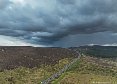 |
| On April 16th 2024 a slow moving CME arrived a full day later than expected generating G1 conditions with a negative Bz component. As darkness fell on a moonlit night the stats didn't look encouraging for anything interesting, especially for inland, however reports began to appear online showing auroral beams readily visible from a wide area which seemed to defy expectations. With clear skies I got the drone in the air and was shocked to easily detect the aurora on camera, then the aurora went into outburst before midnight with red naked eye beams visible above streetlights through Auriga and Perseus. The drone captured this intense cluster of rays beautifully over the Sperrins from near the LP of Cookstown which made for a pleasant surprise. One page report with 3 images. - REPORT. | 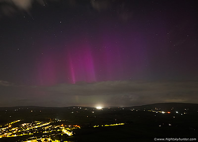 |
| April 26th 2024 - A wonderful clear night over the Sperrins which lured me out into a chilly Spring evening of comet hunting and aurora chasing. I packed my 10" F/5 reflector and drove to Beaghmore and set-up the gear in a lay by under a very dark sky. At 22.45 I made my very first observation of C/2023 A3 Tsuchinshan-ATLAS at mag +10 complete with a tail in Virgo, this comet might become our best since Hale-Bopp this October. Then I detected a faint auroral glow so I drove to the fairy tree in the middle of nowhere. Then suddenly at 1am a formation of ghostly pillars appeared in the sky like phantoms all around the fairy tree which made for a surprising photo opportunity and the perfect end to this fun session. One page report with 6 images. - REPORT. | 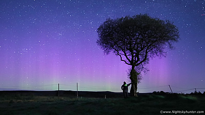 |
| May 10th 2024 - Mega sunspot group unfurling six CMEs and a violent impact at 800km/sec with a Bz of -50, the result was the most severe geomagnetic storm since 2003 and we had perfect clear skies. I was located in a field at Beaghmore in Co. Tyrone beside the famous fairy tree alongside a television film crew. As twilight deepened a truly spectacular aurora manifested covering the entire sky 360 degrees. Pink, green, blue, crimson and purple rays and streamers astonished us while overhead a remarkable corona dominated the sky. This corona took on the forms of birds and even a giant Angel, the display washed most of the stars from the sky and even appeared on the southern horizon. I observed it all night long and obtained my finest astro time lapse of my life. This was easily within my top five aurora experiences ever and a night never to be forgotten! One page report with 34 images and 1 video clip. - REPORT. | 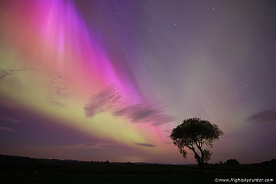 |
| May 20th 2024 - This was a day not to be ignored with high instability on a well defined convergence zone over the far west of the country, our area of choice looked to be Co. Donegal for the best action. Nigel McFarland picked me up and together we went chasing into the target area on the Cz where huge cells and towers were constantly erupting. From our scenic elevated vantage point over looking the hills of Donegal we experienced four thunderstorms however the main storm of the day was a rain making back-building machine which produced at least five hours of constant rain/hail with sporadic lightning which caused flash flooding damage on the flank of Errigal. We had the luxury of observing the entire storm under dry air for much of the time and even captured several c-g bolts on camera. One page report with 12 images and 1 video clip. - REPORT. | 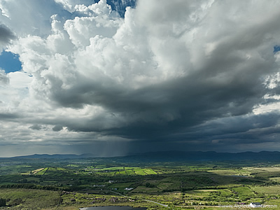 |
| May 21st 2024 - I teamed up with convective forecaster Owain Rice to intercept thunderstorms on a convergence zone near Omagh. After hours of waiting we got thunder however the storms became outflow dominant and unphotogenic. We chased E back into clear air and strong solar heating intercepting a new cell with a menacing base. Later in the day random events had conspired to bring us to Ballyronan Marina along with Nigel McFarland and Colleen Webb. Within min's of our arrival a stunning thunderstorm erupted after 5pm taking full advantage of over 1000j/kg of CAPE, the storm developed a stunning overhead anvil like a volcanic plume with anvil thunder, in fact, the storm produced thunder for an hour with over 340 discharges. We got to enjoy this spectacular photogenic storm in sunshine with the anvil back-lit by the sun with crepuscular rays fanning through the thunderheads, what a day this was! One page report with 16 images and 1 video clip. - REPORT. |  |
| On June 25th/26th 2024 I walked outside to check the sky and was shocked to see a vast type 5 NLC display covering the NW to NE sky sectors & directly overhead. In a panic I drove to Lough Fea where I spent the night observing what I can only describe as an epic display which rivaled the best I had ever seen back in 2009. The NLCs exhibited insane structure in the form of large whirls, knots & herringbone waves all moving in real time while casting shadows on the ground and bathing my dog and I in eerie blue light. This was a spectacular experience. Scientists reckon the 2022 Hunga Tonga undersea volcano seeded the Mesosphere with water droplets causing this NLC storm! One page report with 23 images and 1 video clip. - REPORT. | 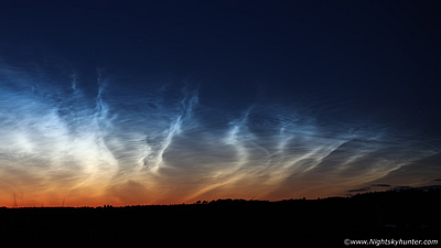 |
| The 2024 storm season has been the worst on record however on July 15th I got treated to a shocking surprise during a funnel hunt with very low expectations. With weak CAPE but notable surface convergence we knew we had a chance of seeing something so I met up with Colleen Webb on Benbradagh Mountain for a day of sky watching. I had just arrived and within a few minutes a funnel cloud appeared from nowhere which took us completely by surprise. It was far away to the NW and looked massive in size and even had that tornadic look, we took images of the funnel despite battling haze and obscuring precip curtains. We soon learned it had been rotating near Letterkenny in Co. Donegal over 25 miles away from our location. This was an impressive vortex and suspected landspout tornado event which was accompanied by second funnel at the same time. One page report with 11 images. - REPORT. | 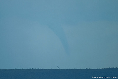 |
| On August 8th 2024 I headed out on a ship chasing adventure to catch an exceptional vessel called the MPI Adventure, a famous off-shore supply vessel and wind turbine installation ship. She was anchored on Drains Bay near Larne so I did the two hour drive and arrived on location during the late evening before sunset where I filmed her with my drone. This ship uses six 60m tall legs to jack herself up out of the water to undertake her operations with greater stability at off-shore wind farms making her an exceptional vessel. My last aerial flight took place in twilight with the MPI lit up with lights when she made for a spectacular scene on the tranquil bay. One page report with 12 images and 2 video clips. - REPORT. | 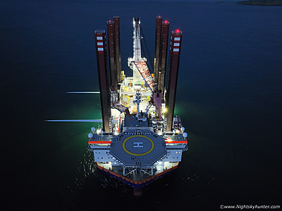 |
| August 11th 2024 brought a much welcomed thunderstorm outbreak when an elevated plume engaged with an active cold front producing hours of night time lightning. A rare event from Ireland which brought the entire Summer thunder drought to an end. I spent the entire night with Colleen Webb on Benbradagh and the back roads of the west watching hours of distant lightning, beautiful orange c-gs, glimpses of a planet conjunction, Perseid fireballs, a surprise aurora, the loudest thunder in a long time and a beautiful G2 aurora the following night. Despite much frustration and not getting the photo opps I wanted seeing all these phenomena at the same time was a very special experience. One page report with 14 images. - REPORT. | 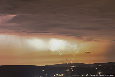 |
| August 28th 2024 was a day I gave little thought to thanks to warm cloud tops and issues with convective depth, however a deeper look at the models showed a classic post-frontal air mass low CAPE high shear day. In fact, with 40 knots 0-2km shear and 40 knots 0-6km shear cells would be low topped but very organized with a chance of rotation, funnels and structure. The day turned out better than expected with two local chases, I captured a distant thunderstorm which was dropping c-gs over Portglenone which even had a small rope funnel. The highlight was one of two structured cells over Tyrone with well formed rain free bases, tilted updraughts, strongly vented precip and vaults, all traits of highly sheared storms, in essence these were almost 'mini supercell' structures which I felt were worth documenting on here. One page report with 12 images and 1 video clip. - REPORT. |  |
| September 4th 2024, dark moonless skies and Milky Way season lured was out on our first big night shoot since Summer. Paul Martin and I decided to meet up and do a return trip to Fanad Head in Co. Donegal, this would be our third night shoot in this area. We made it just in time for sunset and drone filming, then captured derelict fishing boats with twilight stars then made our way to Fanad. It was here where we witnessed a stunning Milky Way in truly dark skies with galactic dust clouds like mist among the stars combined with an explore around the old WWII observation posts. A faint aurora and green airglow also appeared for a great night under the stars. One page report with 17 images. - REPORT. | 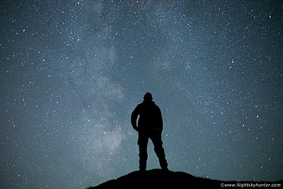 |
| On September 13th 2024 a good CME hit generated a G3 class geomagnetic storm during daylight hours, but would it wait until darkness many hours into the future? with a Bz of -22 and KP7 things were looking good so several friends and I met near Beaghmore within the Sperrins. The aurora faded to a faint glow upon arrival and stayed that way for much of the night, we stuck it out for hours in the frost anyway. Then at 01.00 a glorious outburst happened with auroral rays reaching 60 degrees high with naked eye red and orange colours which we captured over the famous fairy tree in the area, what a photogenic treat this was. One page report with 9 images. - REPORT. | 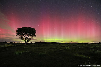 |
| In a year already impressing us with magnificent auroras and with a bright comet about to appear in our evening skies we couldn't have asked for a more action-packed period of night sky treats. Then the sun unfurled a full halo Earth directed CME moving at more than 1000km/sec, the CME hit a day later during the afternoon of October 10th which coincided with clear skies across N. Ireland. Friends and I teamed up near Lough Fea to watch the show unfold. At first it seemed disappointing but after midnight the Bz dropped to -46 resulting in one of the most incredible aurora displays we have ever seen in our lives. 360 degrees of auroral rays and curtains with vibrant naked eye colours while overhead a corona did its silent explosion. A night when dreams really did come true. One page report with 28 images. - REPORT. | 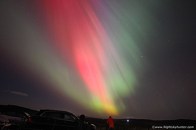 |
| This detailed report documents the build up to one of the brightest comets to grace the northern hemisphere in 27 years, from discovery to a roller coaster ride through possible disintegration then to its final evening apparition. I went through a massive battle with cloud however I finally managed to witness the comet at its best on October 14th when the Earth crossed the orbital plane of the comet generating a rare anti-tail. That evening after a beautiful sunset afterglow on Slieve Gallion I captured the comet in twilight, and in moonlight, with a naked eye dust tail 20 degrees in length making this the best comet since Hale-Bopp in 1997. Then on October 18th I got to watch the comet from An Creagan with a BBC cameraman for a TV series called Chronicles Of The Sperrins. I consider C/203 A3 Tsuchinshan-ATLAS a beautiful comet which I was very lucky to witness. One page report with 18 images. - REPORT. | 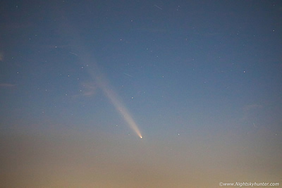 |
| After weeks of grey skies and drizzle a dramatic pattern change resulted in the first cold spell of the season all across Ireland and UK with Arctic air which brought our first high ground snow, including episodes of rare thundersnow. This report documents three days in a row of snow chasing in the Sperrins from November 11th to the 13th which includes scenes from Mullaghmore, Eagle Rock and Slieve Gallion. The most photogenic aspect of this event was on day three on Glenshane Pass when we got treated to sunlit snow and blue skies followed by sunset snow curtains over the wind turbines near Swatragh. The four day cold spell ended with a damaging storm which produced significant flooding which I documented on the Moyola River. A very interesting and much welcomed period of weather. One page report with 24 images and 2 video clips. - REPORT. | 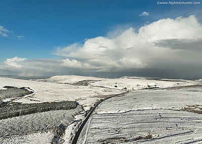 |
Celestial Reprise - my 2024 sky highlights video showcasing various night sky and weather phenomena captured from Ireland and Northern Ireland during the course of the year. All content shot with a DJI Mavic 3 Classic, Canon 5D Mark IV and Canon 600D DSLR cameras, a combination of video footage and time lapse cinematography with a slide show at the end. This year was devoid of many storms, however the huge thunderstorm near Ballyronan during May was the stand out convective event with almost constant anvil thunder, the anvil itself looked like a mushroom cloud exploding in the sky. The night sky however stole the show this year with several epic aurora displays, even the lesser displays were beautiful and very photogenic.
The May 10th G5 was within the top three displays of my life, then the October 10th G4 beat that ranking as the second best display of my life and I've been observing aurora since 1998. These displays were remarkable, rare, severe, nights when dreams came true. Then the June 25th NLC display, that blew me away and caught me off guard during a season when expectations were low, especially during solar maximum. Well this display was supercharged by water droplets from the Hunga Tonga undersea volcano, as a result this NLC display was epic, type 5 brightness with vivid colours and sublime structures, I rank this as my personal best display along with the June 2009 display.
Then comet C/2023 A3 T-A, the brightest northern hemisphere comet in 27 years with a 20 degree naked eye dust tail with an almost full moon in the sky. These events make 2024 a remarkable year for celestial events. In addition to this I have included some nice sunset scenes, fog inversions, dramatic clouds and beautiful snowscapes. Overall it has been a very exciting and unusual year so I hope this video does it all justice. Some of these events. Thanks very much for watching.
Martin McKenna